

Terrain Navigator Pro (TNP) is powerful and easy-to-use desktop and mobile mapping software that contains high-resolution scans of USGS topographic maps, digital terrain/contour/street maps, current aerial photographs and satellite images, and a detailed street layer. These maps and photos can be customized with labels, marks, symbols, lines, routes, tracks, area fills, GIS data sets, and notes. Once you have finished designing your custom maps, use the built-in printing and publishing to create digital and paper prints with text, logos, inset maps, legends, etc. Layers, maps, and photos can be exported to be used in other GIS and CAD software or image editor.
|
- Kevin Lidtka, Professional Surveyor Magazine |
|
TNP is a great time-saver, increasing your return on investment. Don't know how to get to the first point of your survey? TNP can show you the appropriate topographic map, street map, aerial photograph, NGS benchmark and render them all in 3D. You can also exaggerate the 3D view so you get a clear understanding of the terrain you'll be encountering as you get to your project area. |
|
- Find maps quickly - use the graphical index map or search by address, map name, coordinates, zip code, or over fifty types of place names such as rivers and summits.
- Move the cursor over maps or photos, and it displays street addresses. Click on streets or structures to add custom address labels. You can also search for maps and locations by typing an address.
- Find exact coordinates (Lat/Long, State Plane feet/meters, UTM, MGRS, PLSS/TSR, USNG), elevations, and grade instantly.
- Street Overlay included! See current streets mapped on top of topographic maps and aerial photos. Quickly identify roads added since the map was last revised (or photo was taken.) Or, hide the street layer with a click of the mouse to view the unaltered map or photo.
- View high-quality digital USGS maps and aerial photos in 2-D or stunning 3-D. 3-D effects include exaggerated relief, fog, wireframe, and moonlight.
- A TNP exclusive: view traditional USGS maps with collars (borders) for inspection of the entire original USGS map.
- One-click merging of different map sources - providing over 60 unique combinations of topographic, street, and photographic maps.
- Quickly and easily switch between Latitude/Longitude, UTM, MGRS/USNG, PLSS/TSR or State Plane coordinates and/or NAD27, NAD83, and WGS84 datums. Includes unique "alternate coordinate display" allowing side-by-side comparison of different coordinate formats/datums simultaneously.
- Integrated with current National Geodetic Survey control datasheets. Quickly find control points for a project, sort by control level, print reports, and export the raw datasheets. No need to navigate the cumbersome NGS website for these valuable benchmarks.
- Measure distance and area quickly, even across different maps and photos.
- Display on-screen custom grid in any coordinate format – or create your own unique coordinate or magnetic-north-based grid.
- Use Web Links to open web pages based on your current position. Get the weather, look for photos, or get driving directions with a click of the mouse.
- Built-in help pages, tutorials, and a handy USGS map symbol reference guide.
|
|
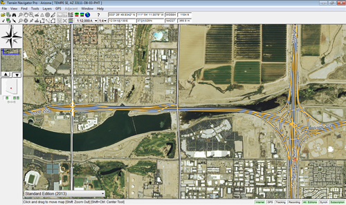 TNP’s servers are chocked full of aerial orthophoto coverage for the entire lower 48 United States. 1-meter (1:12,000 scale) photos are available everywhere, with high-resolution (up to 1:3600 scale) urban imagery in many metropolitan areas. All areas feature color photography taken within the last two years.
- Alternate editions are available for every 1-meter (1:12,000 scale) photo. These alternate editions vary from location to location but include historical photos, black-and-white photos, and color-infra-red photos.
- Need high-resolution satellite images? TNP has you covered too (including Alaska) with recent, detailed photos with or without embedded street labels.
- All photo images can be overlaid with streets, trails, and even combined with topographic maps to create merged hybrid topo photos.
- Unlike online map services, TNP's maps and photos can be downloaded directly to the hard drive – making them available for use when the Internet is not.
- Aerial photos can be printed and published, royalty-free, without the need of watermarks. (Subject to terms outlined in the license agreement.)
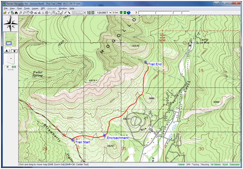
 Customize your maps and aerial photos with labels, marks, symbols, lines, routes, tracks, area fills, and notes.
- Use any system font as symbology for waypoints and markers.
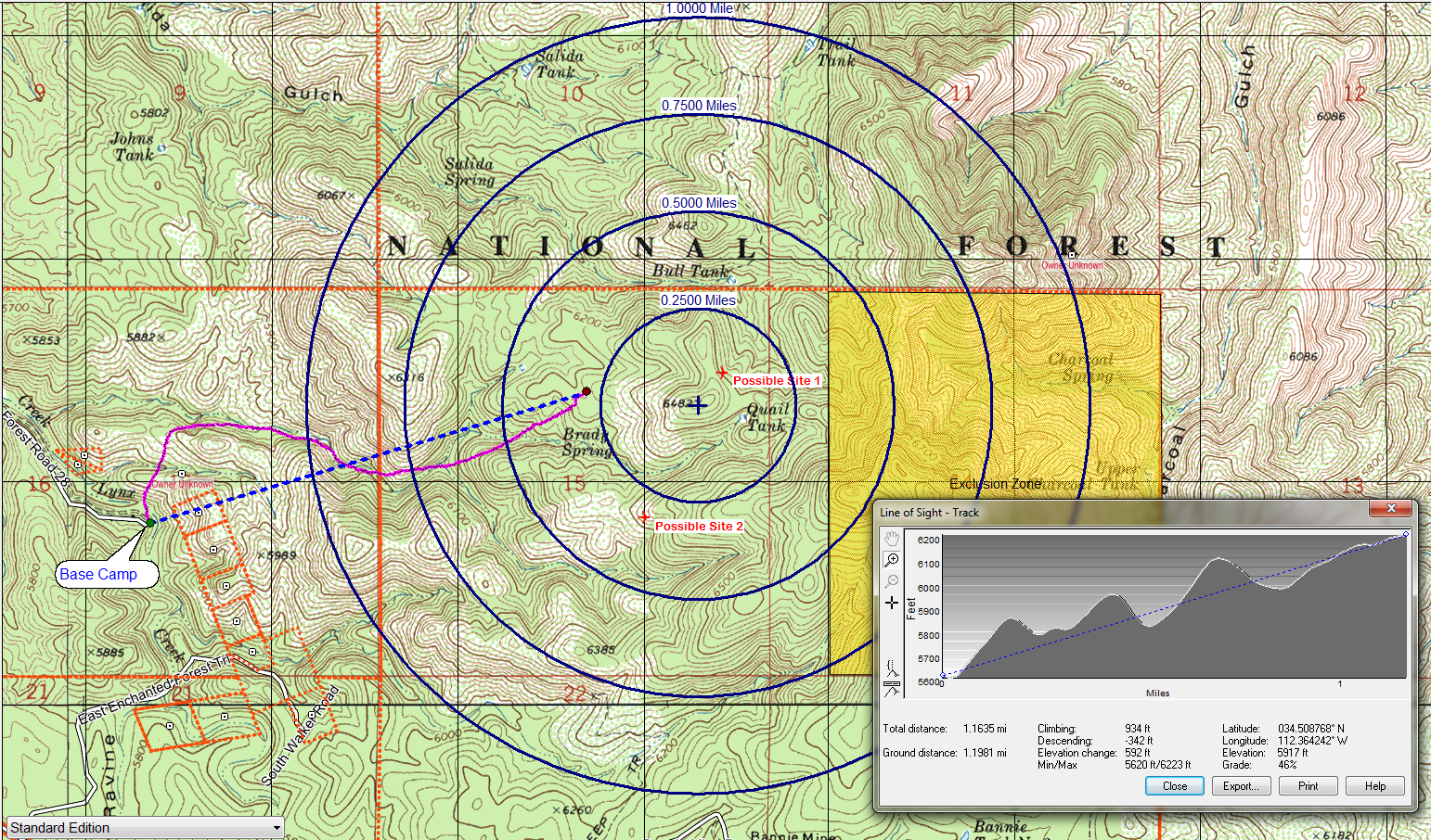
- Range Rings – Show concentric circles based on distance, time traveled, or speed (of live GPS data.) This feature alone makes TNP the choice of Search and Rescue professionals and has saved countless lives! Yet, it remains flexible enough for other applications, such as crop circle irrigation, tower frequency propagation, etc.
- GeoPins - Drag and drop file shortcuts from your desktop onto maps and photos. Instantly link your maps to word documents, spreadsheets, databases, photography, etc.
- GeoTips - Mouse-over maps or photos to determine the street name, address, coordinates, elevation, grade, length, or area.
- Powerful auto-text feature lets you instantly annotate a map or photo with labels containing street name, address, coordinates, elevation, grade, length, or area.
- Range/Bearing Lines – perfect for sight computations; includes intersection calculations. Integrated with GPS for live speed and distance display.
- Integrates with embedded EXIF data in JPG images. Simply drag and drop your photos into TNP, and they automatically appear geo-located on the map! Does your camera not automatically geo-tag photos? No need to be left out of the fun… record a track with your GPS while you are out taking photos, then drag your photos onto the track in TNP – TNP will automatically correlate the time the photo was taken to its position along the track!
- Quickly plot deeds and plans using quadrant metes and bounds.
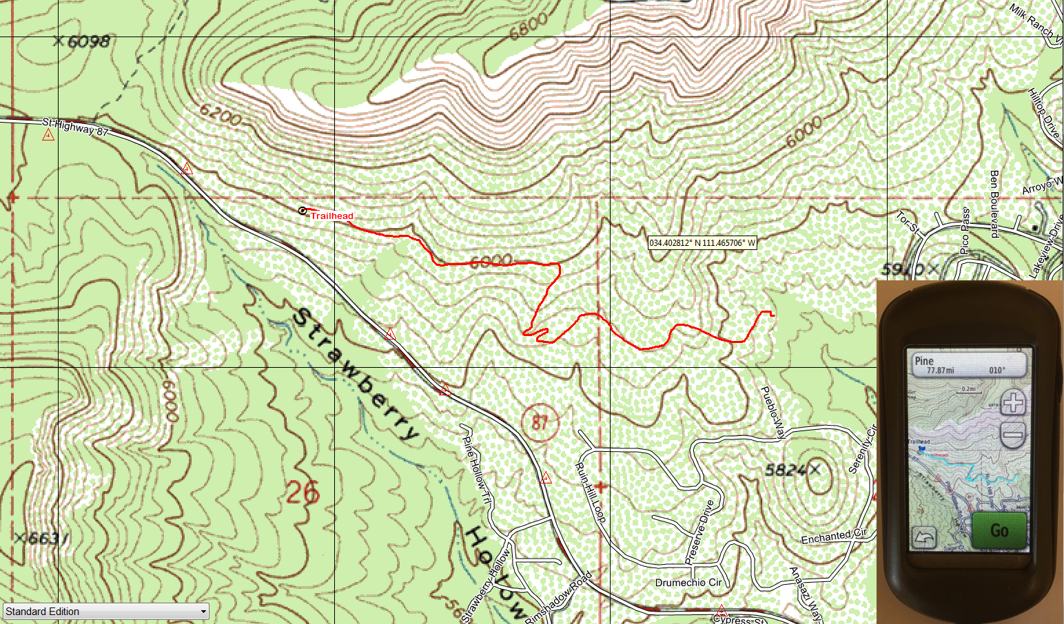
- Create Elevation Profile and Line-of-Sight graphs that include elevation gain and loss calculations. Type-in tower height offsets to instantly determine if the view (or signal) will be obstructed.
- Manage your data layers with Projects. Create custom sets of markers, routes, tracks, polygons, etc. to reflect different needs – and share them with others.
- Create “fly-through” animated video clips of your maps in 3D.
- Automatic backup and restore of important data layers.
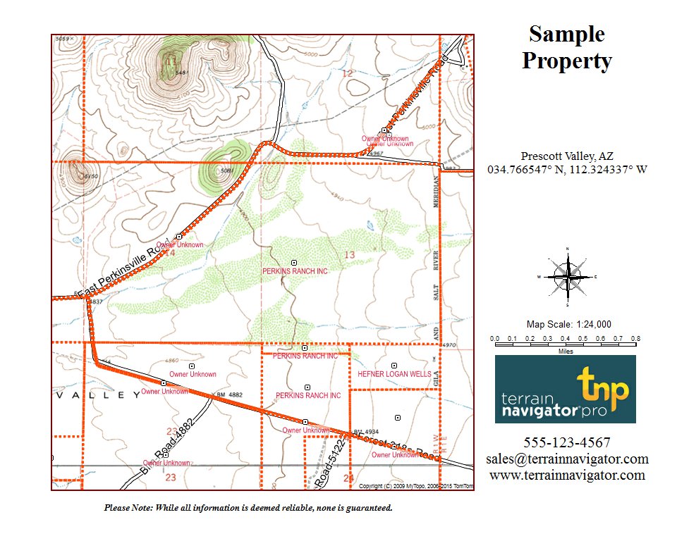 Built-in Desktop Publishing with page blocks. Create custom map pages with text, logos, inset maps, legends, etc.
- Multi-Page printing – print one large map over 2 or more pages.
- Automatically generate map keys/legends based on symbology used in the area
- Export your pages as PDF, JPG, KMZ, TIFF files – or print them directly through one convenient interface.
- Annotate your map pages with an optional Lat/Lon grid, UTM grid, magnetic grid, geographic ruler, and/or compass alignment guide.
- Print maps and photos on standard or large-format printers, with or without USGS borders and legends.
- Use Templates to save your most commonly needed page settings – or choose one that is already ready to go!
- Print quality is excellent, comparable to original USGS paper topographic maps.
- Add 2-D and 3-D maps to PowerPoint presentations and Word documents.
- Create a "3-D fly-around" or "fly-through" (following a preset route) as a short video clip. Email the video clip for use in Windows Media Player, or copy and paste it into PowerPoint to spice up your presentation.
- Email maps to clients, colleagues, and friends.
- Create interactive web pages that display a map segment with a dynamic lat/long cursor. They work in standard web browsers and don’t require Terrain Navigator Pro to view them.
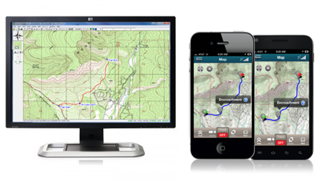
Take advantage of your smartphone's GPS receiver to bring one less piece of equipment into the field using the TNP Mobile Application. Accurately and easily plot positions, follow a premade route, generate a property boundary, take high-res photos and videos and sync them all to your TNP desktop project before you even get back to the office. Click here to learn more.
For conventional GPS devices TNP supports the following:
- Transfer Marks, Routes, and Tracks from your PC into popular GPS receivers to find their location out in the field.
- Transfer Waypoints, Routes, and Tracks from your GPS back to Terrain Navigator Pro to analyze where you've been on a detailed map.
- Custom Map Compatible – display TNP's USGS topographic maps and aerial photos directly on custom map compatible Garmin GPS models. Send maps with a single click of the mouse, or use the Manage GPS Maps window to keep your GPS stocked with official USGS cartography.
- Geocache Ready with LOC and GPX data support.
- Connect a GPS receiver to a laptop and turn it into a moving map display.
- An extensive set of tools for drawing, analyzing, managing, and printing GPS waypoints, routes, tracks, and marks.
- Integrate live positioning information with range rings and range/bearing lines.
- Use GPS Position Averaging to obtain a precise GPS coordinate.
- Easy connections with the most popular GPSs through the automatic Setup Wizard.
- Track time-stamping correlated with image time/date.
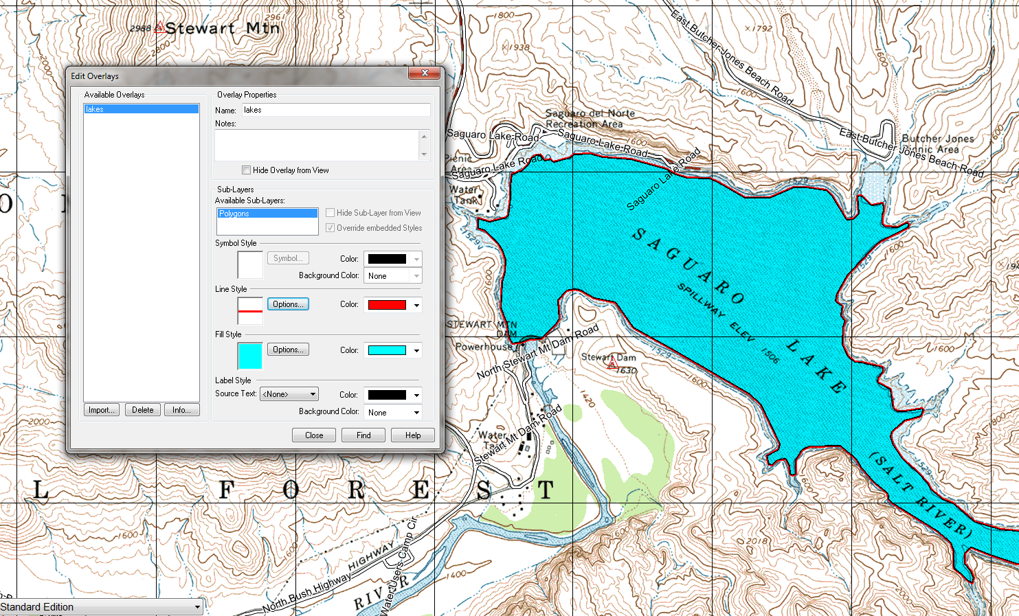 GIS Overlays – display Shapefiles, DXF files, and KML/KMZ markup files directly on TNP's maps and photos. Provides access to thousands of data sets, including property boundaries, land use, and much more. Tools are included to customize display and access embedded text databases.
- Shapefile Export. Create lines, points, and polygons in TNP then transfer them to GIS and CAD applications that accept ESRI Shapefiles, ArcView GEN, GPX, or KML data.
- Export maps and photos to any graphic/image editor (including Photoshop.)
- Integrate the base topographic maps and aerial photos in ArcView, ArcGIS, Intergraph, AutoCAD, MapInfo, MicroStation, ERDAS, and other CAD/GIS applications.
- Export maps and photos in a wide variety of popular geo-referenced formats, including GeoTIFF, DRG, TFW, TAB, and JPG/JPW.
- Customize the projection of exported maps, including into UTM, State Plane, Lambert Conformal Conic, Transverse Mercator, Hotine Oblique Mercator, and Rectified latitude/longitude.
- Specify preferred map datum (NAD27, NAD83, WGS84) and export scale and dpi resolution.
- Export USGS maps with or without borders and legends. Automatically mask maps to include adjacent areas – guaranteeing seamless coverage across multiple quadrangles regardless of reprojection skew.
- Import and use any GeoTIFF map within TNP - including ultra-high-resolution drone photography and historic maps.
- Use the optional Sites Add-on to import DXF drawings, other geo-referenced map formats, and even non-georeferenced maps by placing just three control points!
- Automatically include NGS benchmarks and data sheets with the project area.
- Export elevation data sets as DEM files.
